library(shiny)
library(osmdata)
library(mapview)
library(leaflet)

ui <- fluidPage(
  textInput("city", "City", placeholder = "e.g. Queens"),
  textInput("state", "State", placeholder = "e.g. New York"),
  textInput("country", "Country", placeholder = "e.g. USA"),
  textInput("amenity", "Amenity Type", placeholder = "e.g. pharmacy"),
  actionButton("submit", "Submit"),
  leafletOutput("map")
)

server <- function(input, output, session) {

  observeEvent(input$submit, {
    # Concatenate city, state, and country inputs into a single string
    address <- paste(input$city, input$state, input$country, sep = ", ")
    bbox <- getbb(address)
    query <- opq(bbox = bbox) |>
      add_osm_feature(key = "amenity", value = input$amenity)

    assign("has_internet_via_proxy", TRUE, environment(curl::has_internet))
    sf_obj <- osmdata_sf(query)
    m <- mapview(sf_obj$osm_points)
    output$map <- renderLeaflet({
      m@map
    })
  })

}

shinyApp(ui, server)Introduction
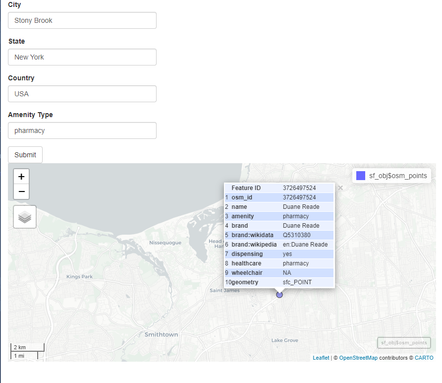
The code is used to create a Shiny app that allows the user to search for a type of amenity (such as a pharmacy) in a particular city, state, and country, and then display the results on a map. Here is a step-by-step explanation of how the code works.
Libraries
The code starts by loading four libraries - shiny, osmdata, mapview, and leaflet. These libraries contain functions that will be used later in the code.
User Interface
The user interface (UI) is defined using the fluidPage function from the shiny library. The UI consists of four text input boxes, a submit button, and a map output. The four text input boxes allow the user to enter the name of a city, state, and country, as well as the type of amenity they are looking for (e.g., pharmacy).
Server Function
The server function is where the “backend” of the app is defined. It is responsible for taking the user inputs, performing calculations or processing on them, and returning the output to the UI.
The server function is defined using the server function from the shiny library. Within the server function, we have an observeEvent function that listens for a click on the submit button. When the submit button is clicked, the function inside the observeEvent is executed.
Concatenating the Address
The first thing that the observeEvent function does is concatenate the user inputs for city, state, and country into a single string. This is done using the paste function. The sep argument specifies that the words should be separated by a comma and space. The resulting string is the address that will be used to search for the specified amenity.
Obtaining the Bounding Box
Next, the code uses the getbb function from the osmdata library to obtain the bounding box for the specified address. A bounding box is a rectangle that contains the entire area of interest (in this case, the specified city, state, and country). The bounding box is necessary to limit the search for the specified amenity to only the specified area.
Creating the Query
The code then creates a query object using the opq function from the osmdata library. The bbox argument specifies the bounding box that was obtained in the previous step. The add_osm_feature function is then used to specify the amenity that the user is searching for. The key argument specifies that we are searching for an “amenity”, and the value argument specifies the specific type of amenity that the user entered (e.g., pharmacy).
Obtaining the Results
The osmdata_sf function is used to retrieve the results of the query. This function returns a sf object that contains the spatial data for the points that match the specified amenity. The resulting sf object is then passed to the mapview function from the mapview library, which creates an interactive map of the results.
Displaying the Map
Finally, the renderLeaflet function is used to display the map in the UI. The m@map argument specifies that we want to display the map that was created by the mapview function. The resulting map is displayed in the leafletOutput that was defined in the UI.
Conclusion
In summary, this R code creates a Shiny app that allows the user to search for a specific type of amenity in a particular city, state, and country,
Full Application
Here is the full script of the app. Please steal this code and modify for yourself, see what you can come up with (PS it needs work for sure).
Voila!